Both the sea ice thickness and sea ice area have fallen to new record lows for this time of the year (22.11.2015), even surpassing all of the worst previous years.
 |
| From Naval Research Laboratory image - view animation |
The normal sea ice area for this time of year is 9,625,000 km2, whereas the sea ice covers currently just 8,415,890 km2,, which makes that 1,209,120 km2 sea ice is missing from the normal (22.11) sea ice area.
The combination image below shows the jet stream (November 23, 2015, left panel) and surface wind (November 24, 2015, right panel).
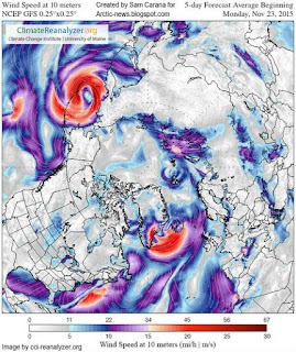
 Jet stream is wavy and strong, showing speeds as high as 219 mph or 352 km/h (at location marked by the green circle). Right panel shows cyclonic winds between Norway and Greenland speeding up movement of sea ice into the North Atlantic.
Forecasts indicate that conditions could continue. The 5-day forecast on the right shows strong winds in the North Atlantic. Note also the cyclonic winds outside the Bering Strait.
Temperatures over the Arctic are forecast to remain much higher than they used to be, with anomalies at the far end of the scale over a large part of the Arctic Ocean showing up on the 5-day temperature anomaly forecast below.
[ further updates will follow ]


Tidak ada komentar:
Posting Komentar